


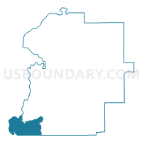
Putnam, Marengo County, Alabama
About
Outline

Summary
| Unique Area Identifier | 522445 |
| Name | Putnam |
| County | Marengo County |
| State | Alabama |
| Area (square miles) | 44.95 |
| Land Area (square miles) | 44.40 |
| Water Area (square miles) | 0.55 |
| % of Land Area | 98.77 |
| % of Water Area | 1.23 |
| Latitude of the Internal Point | 32.03723330 |
| Longtitude of the Internal Point | -88.04243880 |
Maps


Graphs
Select a template below for downloading or customizing gragh for Putnam, Marengo County, Alabama


Neighbors
Neighoring Voting District (by Name) Neighboring Voting District on the Map
- Butler-Lavaca-Mt. Sterling Voting District, Choctaw County, AL
- Fulton City Hall, Clarke County, AL
- Hoboken, Marengo County, AL
- Lusk-Pleasant Valley-Ararat Voting District, Choctaw County, AL
- Nanafalia, Marengo County, AL
- Sweet Water, Marengo County, AL
- Walnut Grove Church, Clarke County, AL
Top 10 Neighboring County Subdivision (by Population) Neighboring County Subdivision on the Map
- Thomasville CCD, Clarke County, AL (6,513)
- Butler CCD, Choctaw County, AL (4,423)
- Sweet Water CCD, Marengo County, AL (2,088)
- Coffeeville CCD, Clarke County, AL (1,329)
Top 10 Neighboring Place (by Population) Neighboring Place on the Map
Top 10 Neighboring Unified School District (by Population) Neighboring Unified School District on the Map
- Clarke County School District, AL (19,941)
- Choctaw County School District, AL (13,859)
- Marengo County School District, AL (8,822)
Top 10 Neighboring State Legislative District Lower Chamber (by Population) Neighboring State Legislative District Lower Chamber on the Map
Top 10 Neighboring State Legislative District Upper Chamber (by Population) Neighboring State Legislative District Upper Chamber on the Map
Top 10 Neighboring 111th Congressional District (by Population) Neighboring 111th Congressional District on the Map
Top 10 Neighboring Census Tract (by Population) Neighboring Census Tract on the Map
- Census Tract 9568, Choctaw County, AL (4,423)
- Census Tract 9733, Marengo County, AL (2,088)
- Census Tract 9577, Clarke County, AL (1,329)
- Census Tract 9576.01, Clarke County, AL (998)